|
To
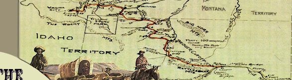
pass over the Bridger Mountains on their way to the Bighorn River,
the emigrant trains had to climb the Bridger Creek drainage and
descend Kirby Creek.
The diaries of Charles Baker, Cornelius
Hedges, and William Haskell discuss the trials
 of traveling up Bridger Creek and down Kirby Creek, although
these streams were not known by their present names at that time.
Baker discussed the route between June 26 and June 29, after his
train completed the first leg from Red Buttes "over very
barren country. . . . [They] Left camp and drove 8 miles to good
water and grass - camped. Left camp . . . traveled 25 mi. over
rough roads & high hills - good water all along over day's
travel." The next day, they "[t]ravelled 7 mi. in p.m.
over very high hills & rough roads." On June 29, the
party "traveled 16 mi. with very little water. . . . came
to Big Horn River & camped." Baker's train traveled approximately
48 miles over the divide; very close to the mileage depicted on
old General Land Office plats and modern topographic maps.
of traveling up Bridger Creek and down Kirby Creek, although
these streams were not known by their present names at that time.
Baker discussed the route between June 26 and June 29, after his
train completed the first leg from Red Buttes "over very
barren country. . . . [They] Left camp and drove 8 miles to good
water and grass - camped. Left camp . . . traveled 25 mi. over
rough roads & high hills - good water all along over day's
travel." The next day, they "[t]ravelled 7 mi. in p.m.
over very high hills & rough roads." On June 29, the
party "traveled 16 mi. with very little water. . . . came
to Big Horn River & camped." Baker's train traveled approximately
48 miles over the divide; very close to the mileage depicted on
old General Land Office plats and modern topographic maps.
William Haskell wrote the following
description of the route after reaching the base of the
Bridger Mountains. On June 30, he "Drove six miles and camped
on a nice
 creek
with an abundance of grass. . . . [July 1] Drove 17 miles over
some desperate hills. . . . hard on all the cattle, but there
is plenty of grass and water. . . . [July 2] Laid in camp today
to let the cattle rest. . . . [July 3] Travelled till about ten
o'clock tonight to find water for the cattle. The road over the
Mountain peaks where there is just room enough for the wagons
to pass; two feet off on either side would have sent us down hundreds
of feet below. . . . took us all to keep the teams in the road
and the wagon right side up. . . . made but a small drive today.
. . . much doubling of teams. . . . [July 4] Travelled eight miles.
. . . stopped to eat our Fourth of July dinner. . . . travelled
on eight miles. . . . [July 5] Drove six miles and came to Wind
[Bighorn] River." Haskell's
mileage totals approximately 45 miles plus "a small drive"
to approximate the map mileage. creek
with an abundance of grass. . . . [July 1] Drove 17 miles over
some desperate hills. . . . hard on all the cattle, but there
is plenty of grass and water. . . . [July 2] Laid in camp today
to let the cattle rest. . . . [July 3] Travelled till about ten
o'clock tonight to find water for the cattle. The road over the
Mountain peaks where there is just room enough for the wagons
to pass; two feet off on either side would have sent us down hundreds
of feet below. . . . took us all to keep the teams in the road
and the wagon right side up. . . . made but a small drive today.
. . . much doubling of teams. . . . [July 4] Travelled eight miles.
. . . stopped to eat our Fourth of July dinner. . . . travelled
on eight miles. . . . [July 5] Drove six miles and came to Wind
[Bighorn] River." Haskell's
mileage totals approximately 45 miles plus "a small drive"
to approximate the map mileage.
Hedges' diary for June 7 through
June 11 is scant on the daily mileage; however, the description
of "rough roads . . . steep hill . . . train stopped many
teams gave out . . . & a hard, hilly road - much delay in
climbing a hill" leaves little doubt this portion of the
route was up Bridger Creek. The route down Kirby Creek on June
10 and 11 is also apparent. "Road lay along the creek all
day. . . . footed it to the river 6 miles, good road - Wind [Bighorn]
river quite a stream."
|
 |