|
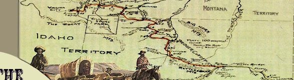
Once the Bridger Trail reached Badwater
Creek, the trail headed north to avoid the impassable Wind River
Canyon and continued up Bridger Creek and over the Bridger
 Mountains near present-day Lost Cabin, Wyoming. At the
summit of the divide, it crossed over to the eastern or south
fork of Kirby Creek, which it descended to the Bighorn River.
Bridger's train crossed the Bighorn River using a large raft or
ferry built from trees felled along the river. The ferry was buried
so it could be used by the trains following Bridger.
Mountains near present-day Lost Cabin, Wyoming. At the
summit of the divide, it crossed over to the eastern or south
fork of Kirby Creek, which it descended to the Bighorn River.
Bridger's train crossed the Bighorn River using a large raft or
ferry built from trees felled along the river. The ferry was buried
so it could be used by the trains following Bridger.
The trail continued along the west
side of the Bighorn River, usually within a mile or less from
the river until reaching the mouth of Nowood Creek. At this point,
the trail left the Bighorn River and proceeded northwest to the
Greybull River.
After crossing the Greybull, the
trail continued west along the north side of the river to the
vicinity of the big bend in the river, at which point it proceeded
north until it reached the Shoshone River.
The trail crossed the Shoshone and
continued northwest following Sage Creek, exiting Wyoming virtually
on the Park/Big Horn County line. The trail continued north until
it reached Clarks Fork of the Yellowstone River near present-day
Bridger, Montana. The trail crossed Sage Creek, heading northwest
approximately three miles to Bridger Canyon and the headwaters
of Bridger Creek (shown on the General Land Office plat as the
Big Horn Basin & Bridger Road). The trail continued due west
along the north side of Bridger Creek and then left Bridger Creek,
heading due north to the crossing of Clarks Fork of the Yellowstone
River, southeast of present-day Bridger, Montana.
In 1864 the Bozeman Trail merged
with the Bridger Trail where it first crossed Rock Creek, approximately
one mile east of present-day Joliet. From this point on, except
for minor variations, the combined trail followed Bridger's route
to Virginia City.
The trail continued northwest across
Rosebud Creek and the Stillwater River near  through Wyoming and Montana, Click to Enlarge, Refer to Acknowledgements #6") Absarokee,
Montana, then west to Bridger Creek and down that creek to the
Yellowstone River. The trail continued west along the south side
of the Yellowstone, crossed Boulder River near Big Timber, Montana,
and continued along the Yellowstone for about sixteen miles to
the crossing near Hunter Hot Springs and present-day Springvale,
Montana, approximately seven miles east of the Shields River. Absarokee,
Montana, then west to Bridger Creek and down that creek to the
Yellowstone River. The trail continued west along the south side
of the Yellowstone, crossed Boulder River near Big Timber, Montana,
and continued along the Yellowstone for about sixteen miles to
the crossing near Hunter Hot Springs and present-day Springvale,
Montana, approximately seven miles east of the Shields River.
A ferry was built to transport the
wagons across the Yellowstone. By July 4, the first three trains
were camped on the south side of the Yellowstone River. Stanfield
had reached the river about noon on the fourth, and "some
of us commenced ferrying and other forded it. It is a beautiful
river near a quarter mile wide a very strong current clear as
crystal very good water to drink and we forded it about 5 and
one half feet deep we crossed over without any serious accident
and camped on the evening of the 4th on the banks of the Yellow
Stone." Hedges also arrived on July 4, and his crossing of
the river was uneventful as well. "Waited till Jacob's train
passed . . . pushed on to ferry. . . . went over on boat. . .
. We are up with Bridger & all. . . . Ferry charge $2.50."
Bridger's trail kept west along the
north side of the Yellowstone, then proceeded north up the Shields
River, west up Brackett's Creek and over the southern end of the
Bridger Mountains, then down Bridger Creek to the Gallatin River
west of present-day Bozeman, Montana. John Jacobs took a few wagons
over what is now Bozeman Pass to the Gallatin River.
Well-rutted roads led from the Gallatin
River to the Madison River, and members of the various trains
headed at will south up the Madison to their destination of Virginia
City.
|