|
John
Baptiste Richard Sr. constructed the
lower Platte Bridge on the Oregon Trail, 6 miles east of old
Fort
Caspar, in time to serve the heavy emigrant traffic in 1853.
Richard Sr. was an early prominent trader on the North Platte
River. In addition to running the bridge he operated a trading
establishment that included a grocery and dry goods store and
a blacksmith shop until 1865. "Richard's associates and employees
were almost all married to women from various Sioux bands";
consequently, their Indian trade was mostly with
 the
Sioux, and undoubtedly some trade occurred with the Northern Cheyenne
and Arapaho as well. Albert Brubaker was in the small train led
by Mr. Millard on their way to rendezvous with a larger train
at the Bridger Cutoff. They reached "Reshaw's [Richard's]
bridge in the latter part of May 1864, and then we met a band
of some 800 Indians, consisting of tribes of Arapaho, Sioux, and
Cheyenne. They were holding a council at that place." the
Sioux, and undoubtedly some trade occurred with the Northern Cheyenne
and Arapaho as well. Albert Brubaker was in the small train led
by Mr. Millard on their way to rendezvous with a larger train
at the Bridger Cutoff. They reached "Reshaw's [Richard's]
bridge in the latter part of May 1864, and then we met a band
of some 800 Indians, consisting of tribes of Arapaho, Sioux, and
Cheyenne. They were holding a council at that place."
In June of 1859 a French Canadian
by the name of Louis
Guinard completed a second bridge--the upper Platte Bridge--on
the North Platte River at the site of historic Fort Caspar.
Guinard constructed a stage station near the bridge and tapped
the early stage traffic along the trail. Guinard was married to
a Shoshoni woman; therefore, his trade was mostly with that tribe.
His post at the time was located at the extreme eastern edge of
Shoshoni territory, and Richard's post, located 6 miles downstream,
was the western edge of the Sioux territory, as roughly established
by the Fort Laramie Treaty of 1851. Suffice to say that each proprietor's
Native American clientele was distinct. Richard purchased Guinard's
operation sometime in 1864.
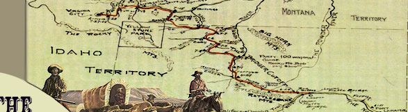
During the spring of 1864, the Richard
bridge was the point of assembly and  departure
for the few wagon trains that used the Bozeman Trail. The Guinard
bridge served the same role for the trains that took the Bridger
Trail to Montana. For example, when William Atchison's train reached
the Lower Platte Bridge, there was considerable debate among members
about whether to take the Bozeman Trail or the Bridger Trail.
On June 20, Atchison "Drove 10 miles to `Lower Platte Bridge'
where Bozeman's cutoff takes in. Had quite a discussion whether
this or the `Bridger' cutoff should be taken. The Bridger men
prevailed and we drove 5 miles further to 'Upper Platte Bridge'
and camped. . . ." Baker did not mention this discussion,
but he did mention that the Bozeman Trail began opposite the lower
bridge. Ethel Maynard, however, remembered that "It was easily
decided to try the new shorter route" - the Bridger Trail.
On June 21, Atchison "Drove to . . . `Red Buttes'. . . .
Here a train of 100 or more wagons was formed for the mutual protection
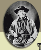
in taking `Bridger's' cutoff. We employed, as a guide, `Rocky
Mountain Bob' paying him for his services $300." departure
for the few wagon trains that used the Bozeman Trail. The Guinard
bridge served the same role for the trains that took the Bridger
Trail to Montana. For example, when William Atchison's train reached
the Lower Platte Bridge, there was considerable debate among members
about whether to take the Bozeman Trail or the Bridger Trail.
On June 20, Atchison "Drove 10 miles to `Lower Platte Bridge'
where Bozeman's cutoff takes in. Had quite a discussion whether
this or the `Bridger' cutoff should be taken. The Bridger men
prevailed and we drove 5 miles further to 'Upper Platte Bridge'
and camped. . . ." Baker did not mention this discussion,
but he did mention that the Bozeman Trail began opposite the lower
bridge. Ethel Maynard, however, remembered that "It was easily
decided to try the new shorter route" - the Bridger Trail.
On June 21, Atchison "Drove to . . . `Red Buttes'. . . .
Here a train of 100 or more wagons was formed for the mutual protection
in taking `Bridger's' cutoff. We employed, as a guide, `Rocky
Mountain Bob' paying him for his services $300."
A new route from the North Platte
was established in 1865 by Connor's column. That same year at
the upper bridge (Guinard's bridge), the Platte Bridge Station
was expanded following the death of Lt. Caspar Collins in the
Platte Bridge Fight and was renamed Fort Caspar. In the fall,
the soldiers at the new post needed building material for huts
and needed fuel for their fires. To save time and labor, they
went down to Richard's bridge, disassembled it, and hauled it
to Fort Caspar to supply this need.
|
 |