|
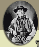
Jim
Bridger respected the territorial boundaries of the Sioux and
did not wish to subject emigrants to the danger of Indian attack.
So he took the first train of miners and emigrants north on what
was to become the Bridger Trail in the spring of 1864. Colonel
Collins temporarily released Bridger from his commission as post
scout at Fort
Laramie on April 30. An emigrant train left Denver about May
1, and headed north to Fort Laramie bound for the Montana gold
fields. Expecting a surge of emigration to Montana, Collins telegraphed
his superiors on April 26 and expressed his concerns for the new
route through the Powder River Basin.
 "Immigration
is coming rapidly; trouble with the Indians may be expected, and
I need "Immigration
is coming rapidly; trouble with the Indians may be expected, and
I need  power
or instructions. . . . A large party is coming from Denver
to go a new route from the Platte to the mines, crossing the Big
Horn and Yellowstone. . . . Other trains are coming with same
object. The route will be at least 200 miles shorter, through
a country that ought to be opened, but a strong military party
will be necessary. . . . I have devoted the last two years to
understanding this country. . . . In this mountain service it
is better to lead than follow immigration. Could I have my way,
it should be sifted, controlled, and guided on designated routes;
not permitted to run wild and make trouble." power
or instructions. . . . A large party is coming from Denver
to go a new route from the Platte to the mines, crossing the Big
Horn and Yellowstone. . . . Other trains are coming with same
object. The route will be at least 200 miles shorter, through
a country that ought to be opened, but a strong military party
will be necessary. . . . I have devoted the last two years to
understanding this country. . . . In this mountain service it
is better to lead than follow immigration. Could I have my way,
it should be sifted, controlled, and guided on designated routes;
not permitted to run wild and make trouble."
Bridger agreed to guide the train
by the safer route west of the Bighorn Mountains and through the
Bighorn Basin, which required no military escort. He left Fort
Laramie on May 20 and headed west up the North Platte River for
the ten-day, 140-mile trek to the Bridger Cutoff west of Red Buttes.
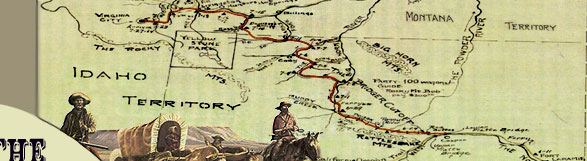
Jim Bridger's trail route departed
the main Oregon Trail west of Red
Buttes, located through Wyoming and Montana, Click to Enlarge, Refer to Acknowledgements #6") along the North Platte River just west of present-day Casper,
Wyoming. Heading in an overall northwestern
direction, the trail skirted the southern end of the Bighorn Mountains,
crossed Badwater Creek, and then proceeded up Bridger Creek, passing
over what today are known as the Bridger Mountains. The trail
descended the northern slope of the mountains via the Kirby Creek
drainage to the Bighorn River in the southern Bighorn Basin. The
trail crossed to the west bank of the river near present-day Lucerne,
Wyoming, and continued downstream to the north, fording the Greybull
and Shoshone Rivers. The trail approached the Montana border in
the vicinity of present-day Frannie, Wyoming.
along the North Platte River just west of present-day Casper,
Wyoming. Heading in an overall northwestern
direction, the trail skirted the southern end of the Bighorn Mountains,
crossed Badwater Creek, and then proceeded up Bridger Creek, passing
over what today are known as the Bridger Mountains. The trail
descended the northern slope of the mountains via the Kirby Creek
drainage to the Bighorn River in the southern Bighorn Basin. The
trail crossed to the west bank of the river near present-day Lucerne,
Wyoming, and continued downstream to the north, fording the Greybull
and Shoshone Rivers. The trail approached the Montana border in
the vicinity of present-day Frannie, Wyoming.
Once in Montana, the trail proceeded
north to Clarks Fork of the Yellowstone River, continued downstream
past present-day Bridger, Montana, to the vicinity of Rock Creek
where the Bozeman Trail joined Bridger's trail. From this point
the two routes continued west as the Bridger Trail south of the
Yellowstone River. The trail crossed the Yellowstone east of present-day
Livingston, Montana. At this juncture, the respective routes of
the Bridger and Bozeman Trails diverged as each guide chose a
different route over the mountains in the vicinity of present-day
Bozeman Pass. The routes then coalesced as a single route into
the recently established community of Bozeman. The trail continued
west, crossed the Gallatin River, and then proceeded to the Madison
River. At that point the trail turned south up the valley of the
Madison to the bustling gold mining community of Virginia City,
Montana Territory.
The Bridger Trail route from Red
Buttes to Virginia City was approximately 510 miles. Based on an average of 15 miles a day, with a one day layover
per week, it would have taken approximately 34 days to travel
the Bridger Trail route. However, time should be factored in for
prospecting forays to the nearby mountain ranges along the way.
After all, that was the principal reason to make the journey.
Bridger's train, leading the way and taking
extra time for road work, traveled the route in about 50 days.
The trains that followed, some of which caught up to and passed
Bridger, made the trip in as little as 34, 36 and 37 days. Howard
Stanfield was with John Jacobs' train when they departed Red
Buttes on May 30, ten days behind Bridger. Stanfield arrived
in Virginia City 42 days later on Sunday July 10 after a trip
that included many layovers, some of which were for prospecting.
Cornelius Hedges left
Red Buttes on June 4, and reached Virginia City on July 10;
a total of 37 days including layovers. James Roberts, Robert
Vaughn, and guide Joseph Knight left on June 10, and arrived
on July 13. This trip of 34 days was the fastest of any Bridger
Trail train. Charles Baker's
train took Bridger's Cutoff on June 22 and arrived in Virginia
City on July 28, for a total of 37 days on the trail. Traveling
with Baker, William Atchison
arrived one day earlier than Baker on July 27.
Based on an average of 15 miles a day, with a one day layover
per week, it would have taken approximately 34 days to travel
the Bridger Trail route. However, time should be factored in for
prospecting forays to the nearby mountain ranges along the way.
After all, that was the principal reason to make the journey.
Bridger's train, leading the way and taking
extra time for road work, traveled the route in about 50 days.
The trains that followed, some of which caught up to and passed
Bridger, made the trip in as little as 34, 36 and 37 days. Howard
Stanfield was with John Jacobs' train when they departed Red
Buttes on May 30, ten days behind Bridger. Stanfield arrived
in Virginia City 42 days later on Sunday July 10 after a trip
that included many layovers, some of which were for prospecting.
Cornelius Hedges left
Red Buttes on June 4, and reached Virginia City on July 10;
a total of 37 days including layovers. James Roberts, Robert
Vaughn, and guide Joseph Knight left on June 10, and arrived
on July 13. This trip of 34 days was the fastest of any Bridger
Trail train. Charles Baker's
train took Bridger's Cutoff on June 22 and arrived in Virginia
City on July 28, for a total of 37 days on the trail. Traveling
with Baker, William Atchison
arrived one day earlier than Baker on July 27.
|
 |