 |
 |
<!--
function MM_swapImgRestore() { //v3.0
var i,x,a=document.MM_sr; for(i=0;a&&i<a.length&&(x=a[i])&&x.oSrc;i++) x.src=x.oSrc;
}
function MM_preloadImages() { //v3.0
var d=document; if(d.images){ if(!d.MM_p) d.MM_p=new Array();
var i,j=d.MM_p.length,a=MM_preloadImages.arguments; for(i=0; i<a.length; i++)
if (a[i].indexOf("#")!=0){ d.MM_p[j]=new Image; d.MM_p[j++].src=a[i];}}
}
function MM_swapImage() { //v3.0
var i,j=0,x,a=MM_swapImage.arguments; document.MM_sr=new Array; for(i=0;i<(a.length-2);i+=3)
if ((x=MM_findObj(a[i]))!=null){document.MM_sr[j++]=x; if(!x.oSrc) x.oSrc=x.src; x.src=a[i+2];}
}
//-->
 |
 |
|
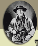
Jim Bridger guided a second train
over the route in September and October 1864. Major John Owen's
diary is the only known recollection of this trip. It details
the day to day progress and events from Red Buttes to as far north
as the Stinking Water  (Shoshone)
River. At that point, the journal ends. Owen had established a
trading post and fort in the Bitterroot River Valley in 1850,
and later became the Indian Agent in the region. He was returning
to Fort Owen with Bridger in the fall of 1864. At least nine trains,
including the first led by Bridger on May 20, traveled over the
Bridger Trail prior to this, establishing a well-worn trace traversed
by hundreds of wagons and untold numbers of stock--mules, oxen,
horses, and cattle. (Shoshone)
River. At that point, the journal ends. Owen had established a
trading post and fort in the Bitterroot River Valley in 1850,
and later became the Indian Agent in the region. He was returning
to Fort Owen with Bridger in the fall of 1864. At least nine trains,
including the first led by Bridger on May 20, traveled over the
Bridger Trail prior to this, establishing a well-worn trace traversed
by hundreds of wagons and untold numbers of stock--mules, oxen,
horses, and cattle.
While traveling over the route a
second time, Bridger, Owen, and members of the train often stopped
to improve, and in places, reroute the trail over the present
day Bridger Mountains.
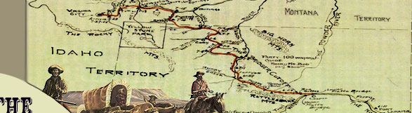
Bridger and Owen left Red Buttes on September 18 and arrived at
Badwater Creek on the September 26. The route appears to be the
same as that traveled by the other trains earlier that summer.
In fact, Owen commented on "the remains of quite a number
of dead oxen strewn along the road." Modification of the
trail route occurred once Bridger's train started the ascent of
the Bridger Mountains. The amount of work, energy expended, and
rerouting of the main road are evident in Owen's diary entries
between September 27 and October 9.
"Travelled 11 miles over a very
rough country road generally good but found some Very steep grades
obliged to double teams in two instances. . . . [28th] Laid ove[r].
. . . [29th] road today passing over a high range of hills and
being very narrow on the ridge with some very steep grades &
heavy pulling Mr Bridger resolved to make a detour through a Vally
[sic] to the right of the ridge cutting a new road through the
vally with good grass and water . . . cutting off about five miles
in the days drive. Turned off the Main road about half a mile
from Camp crossed the creek and moved up the vally found the ground
very good generally for locating a road stoped [sic] twice in
order to fill up the bed of two dry mountain streams. . . . The
course of our days drive will be the location of the road in future.
. . . [30th] laid over to do some grading on the New Cut off.
. . . [October 1] hard pulling up the Hill. . . . camp . . . on
Cotton Wood Creek a tributary of Big Horn. . . . traveled not
over two Miles. . . . [2nd] light fall of Snow lay over to Work
the road. . . . [3rd] Moved the wagons Some two Miles to a small
opening on the Creek. . . . [4th] Cattle lost done some work on
the road. . . . [5th] Done considerable Work on the road &
Movd [sic] camp Some two Miles. . . . [6th] Worked the road &
Moved Camp Some miles . . . to Within a few hundred yds of old
road. . . . [7th] Moved Camp through the Cañon & Came
out onto an open plain Done considerable work on road. traveled
some Six Miles. . . . [8th] Moved some 10 miles on a rolling road
& campd. . . . Men went to river [Bighorn River] for Water.
. . . [9th] Done Some Work on road. . . . Moved the train which
reachd [sic] the river during the Night."
It is difficult to specifically place the changes made in the
route discussed by Owen from his limited description. A careful
reading of the diary entries seems to indicate that, rather than
keeping northwest and crossing West Bridger Creek as is depicted
on the General Land Office plats ("the Main road"),
Bridger may have continued up the main fork of Bridger Creek.
|
|