|

One segment of the historic Bridger Trail was recorded in Hot
Springs County. The segment is located along the top and slope
of an unnamed ridge near the top of the Bridger Mountain Range
northwest of the town of Lysite and southeast of Thermopolis.
This segment was evaluated for its
National Register of Historic Places eligibility. This is a measure
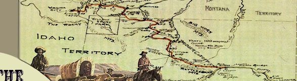
of how important and unique the site is. The Bridger Trail as
a whole is eligible for listing on the National Register because
of its significance as an interregional transportation route through
Wyoming to the gold fields of Montana and because of its association
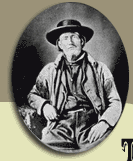
with mountain man and guide Jim Bridger. This segment in particular
was recommended as contributing to the site's overall National
Register eligibility. The segment in this area retains good overall
physical integrity characterized by a gentle swale and lightly
used two-track road. The surrounding viewshed also possesses excellent
integrity of location, setting, feeling, and association due to
the lack of man-made intrusions on the landscape.
The recording and evaluation was
done to mitigate effects to the trail from construction of the
Express Pipeline in Wyoming. Cultural resource mitigation for
the site also included large-scale photographic documentation
of the segment, a published monograph on the Bridger Trail, and
placement of an interpretive sign along the east side of Wyoming
State Highway 16/20 north of Lucerne, Wyoming.
|