|

Cultural resource mitigation for the Bridger Trail segments impacted
by the Express
 Pipeline in Fremont and Hot Springs Counties included large-scale
photographic documentation of the segment, a published monograph
documenting the history and route of the Bridger Trail, and an
interpretive sign was placed along the east side of Wyoming State
Highway 16/20 north of Lucerne, Wyoming.
Pipeline in Fremont and Hot Springs Counties included large-scale
photographic documentation of the segment, a published monograph
documenting the history and route of the Bridger Trail, and an
interpretive sign was placed along the east side of Wyoming State
Highway 16/20 north of Lucerne, Wyoming.
Text on the Interpretive Sign:
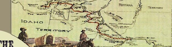
BRIDGER TRAIL - BIGHORN RIVER CROSSING
The Bridger Trail crossed the Bighorn
River near this location in 1864. Passing over the Bridger Mountains
to the southeast, the trail came down Kirby Creek, crossed the
river and proceeded north to the Yellowstone River, then west
to the gold fields in southwestern Montana.
Within months following the 1863
gold discovery at Alder Gulch in present day Montana, a flood
of miners and settlers were traveling to the mining communities
of Bannack and Virginia City. Jim Bridger blazed a new trail in
1864. His trail through the Bighorn Basin west of the Big Horn
Mountains avoided Sioux Indian hostility along the Bozeman Trail
which lies to the east. It also eliminated the extra weeks of
travel along the Oregon Trail-Fort Hall-Bannack road which lies
to the west.
Use of the Bridger Trail was short
lived. However, many variants evolved from the trail in the 1880s
and 1890s. The trail was the ancestor of a freighting network
that connected remote ranches and early communities with Casper,
Wyoming, and Billings, Montana.
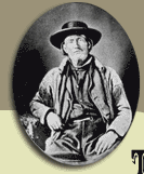
Jim Bridger was the most renowned mountain man, explorer and guide
of the American West. His trail served as a safer route for emigration
to Montana during a period of Native American resistance to Euro-American
encroachment. Equally important, it acted as a foundation for
the development of late nineteenth and early twentieth century
transportation routes that made settlement possible in a region
previously lacking any system of roads.
This interpretive sign is part of
historic site mitigation funded by Express Pipeline Inc.
|