|
This web site was made available
through the support of Burlington
Resources Inc. They
provided the funding for the development of the educational and
interactive pages as well as the historic research and content.
They also provided funding for the physical assessment of the
trail using Geographic Information System (GIS) technologies to
improve the management of cultural resources in the State of Wyoming.
We are grateful for their support.
We would like to thank James A.
Lowe of TRC Mariah Associates Inc. and Robert G. and Elizabeth
L. Rosenberg of Rosenberg Historical Consultants for their
contributions to this web site. James is a professional historian.
He is an expert on the history and condition of the trail and
has published extensively on this route and its history. His book
is entitled: The
Bridger Trail: a viable route to the gold fields of Montana Territory
in 1864
published by the Arthur H. Clark Co, 1999 (ISBN-0-87062-285-4).
He provided the written text, maps, and photographs for the web
pages. Robert and Elizabeth have conducted field examinations
of the trail and have been working as professional historians
in Wyoming for the past twenty five years. Elizabeth conducted
the physical assessment of the trail from Casper to the Montana
State Line using GIS and remote sensing technologies. Her effort
to identify intact physical remains by using satellite imagery
will aid in better management of this cultural resource. We truly
appreciate their expertise and dedication to the preservation
of this unique cultural resource.
REFERENCES
1.
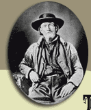
James Bridger, The Pathfinder of the
West. Author:
Honig, Louis O. , Brown-White-Lowell Press, 1951
Illustrations by C.E. Ismert
2.
American Heritage Center: University of Wyoming,
Laramie. http://ahc.uwyo.edu/
The AHC collects, preserves, and catalogs
manuscripts, photographs, maps, audio-visual materials, rare books,
and artifacts related to Wyoming and the West. The AHC houses
the University of Wyoming archives, which contain diverse topics
ranging from economic geology, the petroleum and mining industries,
and transportation, to American culture, conservation, and water
resources. It is home to the papers of many prominent individuals
including statesmen, authors, journalists, artists, pioneers and
entertainers. The AHC also houses the 50,000 volume rare books
collection of the University of Wyoming. Students and scholars
from around the world use the collections of the AHC, and the
AHC sponsors a wide range of scholarly and popular programs including
lectures, concerts, symposia, and exhibits.
3.
Larry Edgar, Western Historical Artist
http://www.westernheritagestudio.com
Western Heritage Studio
P.O. Box 68 Meeteetse, Wyoming 82433
E-mail:jan@westernheritagestudio.com
Toll Free 1-866-868-2111
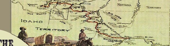
4. Map
of theTerritory of Montana, Sanders,
James U., ed. Society of Montana Pioneers: Constitution, Members,
and Officers, with portrait and maps. Volume 1, Register.
The Werner Company, Printers and Binders, Akron,
Ohio,1899.
5. Regional
Map showing historic emigrant trails. Page 41 of The Bridger
Trail. James Lowe and Suzanne Luhr, TRC Mariah Associates,
Inc.,1999.
6. Map
showing the Bridger Trail through Wyoming and Montana. Page 20
of The Bridger Trail. James Lowe and Suzanne Luhr, TRC
Mariah Associates, Inc., 1999.
7. Holt's
New Map of Wyoming, George
L. Holt Co., Cheyenne, Wyoming, 1885.
Historic Map Collection: American
Heritage Center, University of Wyoming, Laramie.
8.
Pioneers who arrived in the Montana Territory via the Bridger
Trail in 1864. Table from page 137 of The
Bridger Trail, James Lowe, 1999.
9.
Photograph of William Alderson, Montana
State Historical Society.
225 North Roberts, Helena, MT 59620-1201,
P.O. Box 201201
406-444-2694
10.
Photograph of Cornelius Hedges, Montana
State Historical Society. 225 North Roberts, Helena, MT 59620-1201,
P.O. Box 201201
406-444-2694
11.
Photograph of O'Dillon B. Whitford, M.D.,
Montana State Historical Society. 225 North Roberts, Helena, MT
59620-1201,
P.O. Box 201201
406-444-2694
12.
Photograph of Amede Bessette, Montana
State Historical Society. 225 North Roberts, Helena, MT 59620-1201,
P.O. Box 201201
406-444-2694
13.
Photograph of Robert Vaughn, Montana
State Historical Society. 225 North Roberts, Helena, MT 59620-1201,
P.O. Box 201201
406-444-2694
14.
Photograph of Hugh Duncan,
Montana State Historical Society. 225 North Roberts, Helena, MT
59620-1201, P.O.
Box 201201
406-444-2694
15.
Photograph of Wallace Millegan, Montana
State Historical Society. 225 North Roberts, Helena, MT 59620-1201,
P.O. Box 201201
406-444-2694
16.
Photograph of Martha Millegan, Montana
State Historical Society. 225 North Roberts, Helena, MT 59620-1201,
P.O.
Box 201201
406-444-2694
17.
(1) List of Provisions and Equipment recommended in J. L. Campbell's
Emigrant Guide, Idaho:
Six Months in the New Gold Diggings, The Emigrant's Guide Overland.
Chicago: Walsh,
John R., 1864.
(2) Provisions and Equipment listed in Charles Baker's Diary.
Courtesy of Della Mae Jacobs, Kansas City
Missouri, Baker's Granddaughter.
18.
1878 Rand McNally Map, showing Raynolds' and Maynadier's Routes,
the Richard Bridge and Guinard
Bridge, and the departure point for the Bozeman Trail. Rand
McNally Company, William S. Jackson Map Collection, Western History
Department, Denver Public Library, Denver, Colorado, 1878.
19.
Map of Raynolds' 1859-1860 Expedition from the 1868 report. Northern
portion, showing Raynolds' and Maynadier's routes near the Greybull
and Shoshone Rivers. Raynolds, W.F. Report on the Exploration
of the Yellowstone and the Country Drained by that River. 40th
Cong., 2d sess,1868. Historic Map Collection: American Heritage
Center, University of Wyoming, Laramie.
20.
Map of Raynolds' 1859-1860 Expedition from 1868 report. Southern
portion, showing Raynolds' and Maynadier's routes near Red Buttes
and Badwater Creek .
Raynolds, W.F. Report on the Exploration of the Yellowstone
and the Country Drained by that River. 40th Cong., 2d sess,1868.
Historic Map Collection: American
Heritage Center, University of Wyoming, Laramie.
21.
Photograph of Howard Stanfield. Jack Detzler, Indiana University
Press, 1969.
22.
Table showing Bridger Trail Wagon Trains of 1864 in order of departure.
Page 94 of The Bridger Trail, James Lowe,1999.
23.
Photographs of the Bighorn and Greybull River Crossings taken
by James Lowe.
24.
Map showing the city of Casper in relation to Fort Caspar, Richard's
Bridge, and Guinard's Bridge. Murray, Robert A. "Trading
Posts, Forts and Bridges of the Casper Area: Unraveling the Tangle
on the Upper Platte." Annals of Wyoming, 47, no.1
(1975): 5-30.
25.
USGS 7.5" Topographic Map, Lovell, Wyoming, Quadrangle, showing
a Bridger Trail Crossing on the Shoshone River. Route drawn by
James Lowe based on the 1883 General Land Office Plat Map, 1999.
26.
Inscriptions on Signature Rock, S. Magee - July 14, 1864;
D. A. Lecky - July 14, 1864; Benton Garinger - June 19, 1864;
Wm. Henry - July 14, 1864.
27.
Photograph of the W. D. Walden inscription taken in 1966. American
Heritage Center: University of Wyoming, Laramie. http://ahc.uwyo.edu/.
Modern photograph of W.D.
Walden taken by James Lowe. Courtesy of Lorraine "Tomie"
Metzler, owner of the Bow and Arrow Ranch.
28.
Photograph of Charles and Lydia Baker. Courtesy
of Della Mae Jacobs, Kansas City Missouri, Baker's Granddaughter.
29.
Route of the Shoshoni Buffalo Hunt in 1874 led by Chief Washakie.
Map drawn by Grace Raymond Hebard. Historic Map Collection: American
Heritage Center, University of Wyoming, Laramie. http://ahc.uwyo.edu/.
30.
Photograph of Chief Washakie and Shoshone Warriors. Washakie,
An account of Indian Resistance of the Covered Wagon and Union
Pacific Railroad invasions of their territory, 1930. Hebard,
Grace Raymond, Arthur H. Clark Company, Cleveland, Ohio.
31.
Historic Trail reenactment 2001, photograph by Sam Trautman,
trautman@uwyo.edu
32.
Bridger Trail Book Review, Robert M. Utley.
33.
Photographs of Bridger Trail segments and scenes taken by James
Lowe.
34.
Virtual World created by Sam Trautman, Wyoming State Historic
Preservation Office. trautman@uwyo.edu
35. SITE HEADER-
36.
Farm Wagon typically used by overlanders during the early and
middle part of the migration period. Photograph by Sam Trautman,
Wyoming State Historic Preservation Office.
trautman@uwyo.edu
|
 |