|
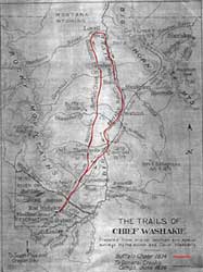
CHIEF WASHAKIE/SHOSHONI BUFFULO HUNT
Trails in and out of the Bighorn
Basin continued to be used primarily by Indians following the
end of the American fur trade in the 1840s, until Bridger blazed
his trail in 1864. From that date through the reservation period
of the late 1860s and 1870s and prior to white settlement in the
basin, the principal trail users continued to be Indians when
they departed the reservations for their fall buffalo hunt. The
Shoshoni were allowed to make a seasonal bison hunt after settling
on the Wind River Reservation in
 1868. As late as 1874, and possibly for a few more years, the
Shoshoni traveled to the Bighorn Basin to hunt. James Patten,
government teacher on the reservation, accompanied Chief Washakie
and the entire (1,800) Shoshoni tribe in October 1874. From Wind
River they crossed over the Owl Creek Mountains into the southwestern
portion of the basin. According to Patten, they found bison "herds
on the Gooseberry about forty miles from its mouth," or west
of the Bighorn River, where they killed "one hundred and
twenty-five buffalo." At this juncture, the tribe migrated
north to the Shoshone River, now using part of Bridger's route
laid out 10 years before. "[T]he trail was taken straight
across country, crossing the Greybull about where the town of
Otto now stands. Thence straight on to the Stinking Water [Shoshone
River] . . . This we struck at the old Bridger Crossing, and followed
down its banks to its mouth, and made camp among those grand cotton
trees on the Big Horn River." Thus in the end, Indian trails
first used by American trappers, traders, and emigrants had evolved
full circle, the tribes had come to use improved roads pioneered
long ago by their forefathers.
|
 |